Good morning. This is Ian Hoyer with the Gallatin National Forest Avalanche Forecast on Friday, March 15th at 7:00 a.m. Today’s forecast is sponsored by Highline Partners and Spark R&D. This forecast does not apply to operating ski areas.
There is no new snow. Temperatures are in the teens F. Winds have been all over the place, shifting to all the cardinal directions somewhere in the advisory area over the last 24 hours. They’ve been blowing at 10-20 mph, except in Island Park where gusts are reaching 60 mph. Winds today will shift more consistently to north and east by this afternoon at 10-20 mph. High temperatures will be in the 30s and 40s F under sunny skies. The next chance for snowfall is later next week.

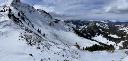
Avalanche conditions remain dangerous. Over the last week there have been a series of really big, natural and human triggered avalanches (Blackmore video, Beehive video, Beehive photos, Cooke City activity list). These slides are breaking on the weak layers near the base of the snowpack. Yesterday there was another, outside of our advisory area in the Absaroka Range, that broke 3-4 ft deep, 1/4 mile wide and was triggered from hundreds of feet away (details).
Slides may also break beneath wind drifts that formed from the 6”-10” of snow that fell mid-week. Warm temperatures and sun today will also likely lead to loose wet avalanches.
Be patient. Avalanches have been breaking on the basal weak layers for days after the end of storms this year. Things will likely start to stabilize with a stretch of high pressure ahead of us, but we’re not there yet.
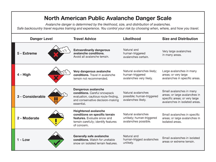
Human triggered avalanches are likely and the avalanche danger is CONSIDERABLE.

The general snowpack structure is the same in the Lionhead and Island Park areas as elsewhere, the snowpack is just a bit deeper so it’s getting harder to trigger slides and we’ve seen less recent avalanche activity. Getting into steep terrain still means rolling the dice with the possibility of triggering a huge, likely unsurvivable avalanche. If you’re going to enter the casino, stack the odds in your favor by traveling one at a time, carrying rescue gear and having a partner watching from a safe spot while you’re on steep slopes. Avalanches could also break in wind drifts of recent snow and be wary of a wetting snow surface bringing wet loose avalanche concerns to the table.
Human-triggered avalanches are possible and the avalanche danger is rated MODERATE.
In the Bridger Range we have seen less recent loading and little recent avalanche activity on deeper weak layers. The weak snow is still there, but the issues you’re more likely to encounter are higher in the snowpack. Wind drifts and wet surface snow could cause smaller, but still consequential, avalanches. Be on the lookout for cracking in wind drifts and wet snow more than a couple inches deep as signs to get out of steep terrain. Choose slopes with fewer obstacles in the runout and stick to good travel practices in case you do end up being the unlucky one who triggers a bigger slide.
The avalanche danger is MODERATE.
If you venture out, please fill an observation form. It does not need to be technical. Did you see any avalanches? How much snow is on the ground? Was the wind moving snow? Simple observations are incredibly valuable. You can also contact us via email (mtavalanche@gmail.com), phone (406-587-6984), or Instagram (#gnfacobs).
Upcoming Avalanche Education and Events
Our education calendar is full of awareness lectures and field courses. Check it out: Events and Education Calendar.
TONIGHT and TOMORROW in Cooke City: Friday at The Antlers at 7 p.m., Free Avalanche Awareness and Current Conditions talk, and Saturday from 10 a.m.-2 p.m. at Round Lake Warming Hut, Free Rescue Practice. This is the last weekend this program will be running this season.
Loss in the Outdoors is a support group for those affected by loss and grief related to outdoor pursuits. Check out the link for more information.
On Tuesday, a backcountry skier was caught and killed by an avalanche near Lost Trail Pass. Preliminary information is available here.