Good morning. This is Alex Marienthal with the Gallatin National Forest Avalanche Forecast on Monday, March 11th at 7:00 a.m. Today’s forecast is sponsored by Gallatin County Sheriff Search and Rescue and Alpine Yamaha in Livingston. This forecast does not apply to operating ski areas.
There is no new snow. Wind has been out of the southwest at 15-25 mph with gusts of 35-65 mph. Temperatures are low 20s to low 30s F. Today, temperatures will reach mid 30s F, and wind will be southwest-west at 10-20 mph. Snow showers will arrive in the southern half of our forecast area later this morning, and in the north this evening, with 1-3” possible by tomorrow morning.
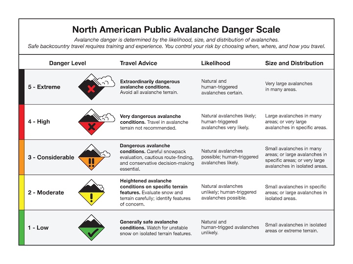
Near Cooke City dangerous avalanche conditions exist and large, human-triggered avalanches are likely. We recommend avoiding slopes steeper than 30 degrees and giving them a wide berth if crossing below. On Saturday on Sheep Mtn. a rider triggered a very large avalanche while crossing below a steep slope, they were partially buried and luckily ok (photos). Later that afternoon a large natural avalanche ran on the north side of Republic Mtn (photos). This natural is especially notable because there had been a couple days without recent snow or wind-loading. Yesterday, we found another big avalanche north of Miller Mtn. which I assume was human-triggered on Saturday (video, photo), and we saw recent large avalanches on the steep walls of Miller Crk. (photo).
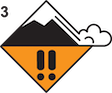
Avalanches have been breaking many feet deep and hundreds to thousands of feet wide, failing on weak snow at the bottom of the snowpack. The largest was Thursday on Henderson Mtn. where a snowmobiler triggered a slide that broke over 2000’ wide and 6-10’+ deep (aerial video). Also, on Friday two slides on different sides of Scotch Bonnet Mtn. were likely triggered by snowmobilers (details, details, Scotch Bonnet video), and there were recent natural avalanches on Scotch Bonnet (photo) and in Yellowstone National Park (Barronette photo, Abiathar photo). These are only a selection among possibly the most widespread large avalanche cycle I have ever seen (activity log). Today, large human triggered avalanches are likely, and avalanche danger is CONSIDERABLE.

A person can trigger avalanches breaking many feet deep on buried persistent weak layers or shallower slides breaking below recent slabs of wind-drifted snow. While the likelihood of triggering avalanches has decreased since our last round of snow, the consequences of being caught remain high. Yesterday Dave skied at Hebgen Lake and made this video to highlight the importance of terrain selection, especially while snowpack assessment is tricky with deeply buried weak layers. If you choose to travel on or below slopes steeper than 30 degrees, choose terrain carefully to minimize exposure to terrain traps like thick trees or confined gullies, and follow standard safe travel protocols of crossing steep slopes one at a time and watching each other from safe locations.
A few avalanches over the weekend show what is possible. In Beehive Basin near Big Sky, on Friday skiers dropped a cornice that triggered an avalanche up to 6’ deep, 500’ wide and took out their skin track (details and photos), and on Saturday a natural avalanche broke from a cornice fall (photos). On Friday on Saddle Peak in the Bridger Range skiers triggered avalanches of wind-drifted snow that were 1-2' deep, and up to 200' wide (details and photos). Although these were smaller than the slides in Beehive they have large consequences, especially if they carry you over cliffs like those on Saddle Peak. Luckily nobody was caught in these slides. Skiers in the northern Bridgers and Hyalite also noted recent large natural avalanches that occurred earlier in the week (Bridgers photos, Hyalite photos).
If you consider riding or crossing below steep slopes, choose simple, low-consequence terrain and slopes without previous wind-loading, and follow safe travel protocols. The avalanche danger is rated MODERATE.
If you venture out, please fill an observation form. It does not need to be technical. Did you see any avalanches? How much snow is on the ground? Was the wind moving snow? Simple observations are incredibly valuable. You can also contact us via email (mtavalanche@gmail.com), phone (406-587-6984), or Instagram (#gnfacobs).
Upcoming Avalanche Education and Events
Our education calendar is full of awareness lectures and field courses. Check it out: Events and Education Calendar.
Next weekend in Cooke City: Friday at The Antlers at 7 p.m., Free Avalanche Awareness and Current Conditions talk, and Saturday from 10 a.m.-2 p.m. at Round Lake Warming Hut, Free Rescue Practice.
Loss in the Outdoors is a support group for those affected by loss and grief related to outdoor pursuits. Check out the link for more information.
We are deeply saddened to share the loss of two avalanche professionals from the Pacific Northwest last week. Nick Burks, who was a forecaster for the Wallowa Avalanche Center died in an avalanche accident while skiing with a friend on Wednesday, March 6 (details). Matt Primomo, who was an avalanche forecaster for the Northwest Avalanche Center, died in a non-avalanche related accident on Thursday, March 7. Our thoughts are with our colleagues, their friends, families, and the communities which these people were a major part of.