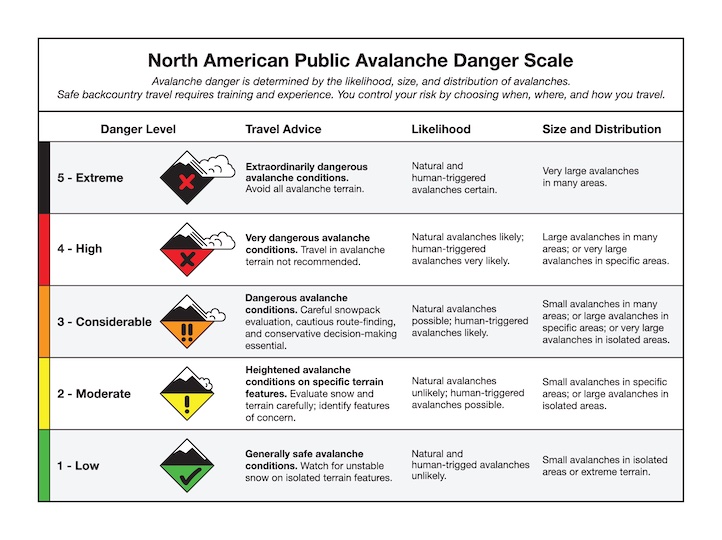
Good morning. This is Doug Chabot with the Gallatin National Forest Avalanche Forecast on Thursday, January 18th at 7:00 a.m. This information is sponsored by Klim and Avalanche Alliance. This forecast does not apply to operating ski areas.
AVALANCHE WARNING
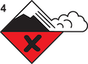
We are issuing a Backcountry Avalanche Warning for the area around Cooke City. Over a foot of snow and strong wind are overloading a weak snowpack, creating very dangerous avalanche conditions. Natural and human triggered avalanches are likely. Avalanche terrain and avalanche runout zones should be avoided. The avalanche danger is rated HIGH on all slopes.
This warning will expire or be updated by 6:00 a.m. on Friday, January 19th.
In the last 24 hours Cooke City received 10+” of new snow, 5” in the Bridger Range, and 2-3” everywhere else. West to northwest wind is averaging 20-50 mph with gusts of 75 mph. Mountain temperatures are in the single digits F around Bozeman and teens elsewhere. Snowfall has mostly ended, winds will still be strong, but lessen to 20-35 mph. Sunshine may pop through the clouds and tonight the mountains could get a trace to an inch of snow.
Avalanche Warning
There is an Avalanche Warning in Cooke City and triggering avalanches is very likely. The mountains received over a foot of snow at higher elevations measuring about an inch of snow water equivalent, (SWE). Wind is strong and loading slopes at a fast clip. Ian is in Cooke City and was able to trigger a small slide from 100’ away (video). This, along with daily observations of cracking, collapsing and avalanche activity, are clear signs that the backcountry is “game on” and dangerous. Heed Ian’s advice and stay out of all avalanche terrain and also from underneath these slopes (runout zones) since they can be triggered from below.
The avalanche danger is HIGH on all slopes.
The mountains around West Yellowstone and Island Park are unstable and dangerous and very close to Avalanche Warning criteria. Although only 2-3” of snow fell, the snowpack is extremely weak and wind has been blowing strong and loading slopes, especially at the ridgelines. Two days ago, Ian and I rode around Lionhead and had lots of cracking, collapsing and saw recent avalanche activity (video). A few inches of snow and strong wind made the situation even worse. Do not get into avalanche terrain today and be extra careful about traveling in gullies or below open slopes. Avalanches can be triggered from below.
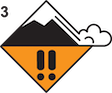
The avalanche danger is rated HIGH on all wind-loaded slopes and CONSIDERABLE on all others. In other words, triggering avalanches is likely on all slopes.
The Bridger Range received 5” of new snow (.7” SWE) with 15-40 mph west wind loading slopes. The snowpack is weak and supporting .7” of SWE will cause it to struggle and become very unstable. Wind is loading slopes at all elevations which a skier noted in Frazier Basin yesterday (observation). I do not recommend getting on or underneath steep slopes today. I expect triggering avalanches to be likely, especially on any slope that had been wind-loaded.
The avalanche danger is HIGH on wind-loaded slopes and CONSIDERABLE on all others.
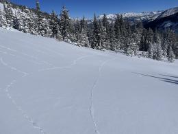
The entire Gallatin and Madison Ranges received 3” of snow. At the ridgelines N-NW wind has been very strong with gusts of 75 mph, which is violent enough to make standing upright impossible. Wind at lower elevations is strong and swirly. Snow is being stripped, moved into drifts and creating unstable avalanche conditions. In areas with wind loading avalanches are very likely to be triggered. Reports from Taylor Fork (observation) and Bacon Rind (observation) indicate lots of cracking and collapsing. Dave found weak snow on Mt. Blackmore and in Beehive Basin a few days ago (Beehive video, Blackmore video). Off the ridgelines it might be difficult to ascertain what has been wind-loaded or not.
Given the new snow and strong wind at all elevations, the avalanche danger is rated CONSIDERABLE on all slopes.
If you venture out, please fill an observation form. It does not need to be technical. Did you see any avalanches? How much snow is on the ground? Was the wind moving snow? Simple observations are incredibly valuable. You can also contact us via email (mtavalanche@gmail.com), phone (406-587-6984), or Instagram (#gnfacobs).
Upcoming Avalanche Education and Events
Our education calendar is full of awareness lectures and field courses. Check it out: Events and Education Calendar.
Every weekend in Cooke City: Friday at The Antlers at 7 p.m., Free Avalanche Awareness and Current Conditions talk, and Saturday from 10 a.m.-2 p.m. at Round Lake Warming Hut, Free Rescue Practice.
We offer Avalanche Fundamentals with Field Session courses targeted towards non-motorized travelers in January and one geared towards motorized users. Sign up early before they fill up.
January 18, 4 p.m., Darren Johnson Avalanche Education Memorial Fund - Pint Night, Beehive Basin Brewery, Big Sky. Information HERE.
King & Queen 2024, 3 February 2024. Form a team or sign up individually to hike laps on the Bridger Bowl ridge to fundraise for the Friends of the Avalanche Center.
Loss in the Outdoors is a support group for those affected by loss and grief related to outdoor pursuits. Check out the link for more information.
KING AND QUEEN OF THE RIDGE, FEBRUARY 3rd
Do you like to hike? Do you like to ski? Then the King & Queen of the Ridge is for you. Hike, ski and raise money for the Friends of the Avalanche Center in their 2nd biggest fundraiser of the year. Join the effort to promote and support avalanche safety and awareness! Fundraising prizes for the top 5 individuals who raise over $500. No racing is necessary to compete for the fundraising prizes. Info is HERE. Race participants for the February 4th event must register separately with Bridger Bowl HERE.
On Sunday, a skier was killed in an avalanche in the Salt River Range, Wyoming. This is the third avalanche fatality of this season all of which occurred last week (avalanche near Lookout Pass in Idaho, avalanche at Palisades Tahoe in California).