Good morning. This is Dave Zinn with a spring weather and snowpack update on Friday, April 28th. The Gallatin National Forest Avalanche Center has stopped issuing daily avalanche forecasts for the season. This is our final spring bulletin for the year. We will continue to share relevant snowpack and avalanche information on our social media channels.
Bridger Bowl is closed, and backcountry conditions exist. There is no avalanche mitigation or ski patrol rescue. In case of emergency, call 911. Please stay clear of chairlifts and other equipment.
On Thursday, the mountains received 1-5” of snow, favoring Hyalite Canyon and the areas near West Yellowstone and Cooke City. On Friday morning, temperatures are in the teens to 20s F, and winds are 10-20 mph from the west to northwest.
On Friday, mountain temperatures will push into the 40s F under sunny skies. Sun will persist, and temperatures will be in the 50s and 60s F through the weekend. Nighttime temperatures will largely stay above freezing except for the West Yellowstone and Cooke City areas. Winds will be 5-15 mph from the northwest to southwest. There will be no precipitation until early next week when the chance of rain and high-elevation snow showers arrives Monday night.

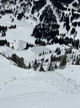
On Thursday, the mountains received 1-5” of new snow, favoring Hyalite Canyon and the areas near West Yellowstone and Cooke City. Expect this snow to shed from steep slopes as it gets wet under a warm spring sun later Friday morning. Small, wet snow avalanches pack a punch and can easily knock a skier or rider off their feet and push them into obstacles. Move to cooler aspects (or to dry trails, rivers, and rocks) when the snow surface gets wet or when you see the first signs of instability, such as roller balls or avalanche activity. Look at the photos of recent wet snow avalanches at Bridger Bowl for an example of what will likely occur.
This weekend, it will get hot. Daytime mountain temperatures in the 50s and 60s F will last well into next week, with nighttime temperatures remaining above freezing in most areas outside of West Yellowstone and Cooke City. The likelihood and potential size of wet snow avalanches will increase through the weekend and next week. The weakening of the snowpack will start superficially and progress deeper as the melt intensifies. We may see large and destructive wet-slab avalanches before the next solid freeze.
The travel advice and snowpack assessment for wet snow instabilities are relatively simple. Conditions are generally stable if the snow surface has a strong, supportable crust. As the crust breaks down, conditions are destabilizing. Be off and out from under steep terrain by the time you sink into wet, sloppy snow more than a few inches deep. With temperatures remaining above freezing, we may not get the stable portion of this diurnal cycle in all areas.
Don’t neglect your exit strategy from the mountains. Slopes in lower elevations will become unstable earlier than in upper elevations and north-facing terrain. I’ve been forced to consider alternative exits in the past as I traveled back through lower elevations, feeling foolish as I realized that I’d been trapped by wet snow and poor planning. Additionally, give cornices along ridgelines a wide berth and avoid slopes below them as they are known to collapse this time of year (Mt. Abundance, Northern Madison Range).
This is our final regular spring bulletin of the season. Have a safe and fun spring wherever your adventures take you.
We will continue to share relevant avalanche and snowpack information on our website, social media and in special bulletins as necessary. If you get out, please send us your observations, no matter how brief. You can submit them via our website, email (mtavalanche@gmail.com), phone (406-587-6984), or Instagram (#gnfacobs).
Wet snow avalanches are the primary concern in the Centennial Mountains. The weakening of the snowpack will start superficially and progress deeper as the melt intensifies this weekend. Wet snow avalanches will likely increase in frequency and size. Conditions are generally stable if the snow surface has a supportable crust. As the crust breaks down, conditions are destabilizing. Be off and out from under steep terrain by the time you sink into wet, sloppy snow more than a few inches deep.
Info and Reminders
We are updating our avalanche and weather log daily and posting relevant changes to the avalanche conditions so you can track the weather and how it affects the snowpack.
Bridger Bowl Ski Area is closed, and ski patrol is no longer performing rescues and making terrain closure decisions for you (video). Commonly traveled routes such as the North Bowl Road and any slope steeper than 30 degrees are avalanche terrain (i.e. most of the Ridge and Schlasman’s terrain). Other groups above and below you may complicate principles of safe travel.
Hyalite Canyon road is closed for motorized use until May 16.
May 4-5 is Give Big, a fundraiser for non-profits in the Gallatin Valley. The Friends of the Avalanche Center are accepting donations. If you use our services we would be grateful for any financial support. Thank you for a great season.