Good morning. This is Alex Marienthal with the Gallatin National Forest Avalanche Forecast on Monday, February 27th at 7:00 a.m. This information is sponsored by Cooke City Motorsports, Stronghold Fabrication and Alpine Orthopedics & Sports Medicine. This forecast does not apply to operating ski areas.
This morning there is 5-6” of new snow near Cooke City, West Yellowstone and Big Sky, and 2-3” near Bozeman. Temperatures are single digits to teens F and wind is west-southwest at 15-25 mph with gusts of 35-45 mph. Today, temperatures will reach high teens to mid-20s F, and wind will be west-southwest at 15-30 mph. Near West Yellowstone and Cooke City could get 2-4” of snow today and tonight with a trace to an inch elsewhere, and more snow expected tomorrow.
Near Cooke City, the last couple days there were multiple natural and human-triggered avalanches with a few people caught, and luckily nobody injured. Yesterday two skiers triggered and were carried by a 2 foot thick slab of wind-drifted snow (photos and details). On Saturday, a large natural avalanche buried the Daisy Pass road (photos and details), a skier triggered and was caught in an avalanche near Round Lake (photo), and a snowmobiler was partially buried on Mt. Abundance (details). Over the weekend large natural avalanches were also seen on Henderson Mountain (photo), in Sheep Creek (photo) and Republic Creek (photo). On Saturday, in the southern Gallatin Range skiers intentionally triggered a small wind slab (video), and at Lionhead a rider saw recent avalanches on wind-loaded slopes (photo).
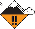
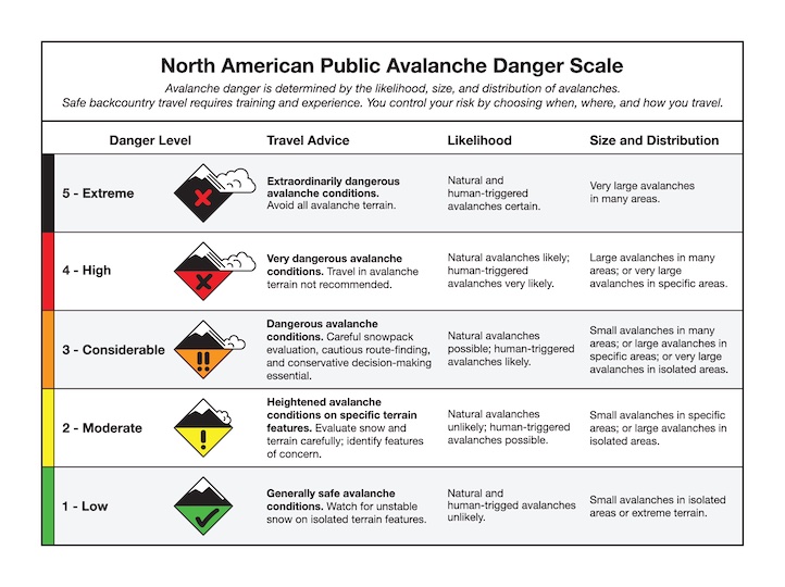
Strong winds drifted last week’s 2-4 feet of snow into thick slabs. Recent widespread avalanche activity is a sign these wind slabs remain likely for a person to trigger. Today’s 5-6” of new snow will be drifted into fresh slabs that will add weight and may cause deeper avalanches to be triggered or break naturally. Avoid travel across steep wind-loaded slopes and minimize time spent below them. On non-wind loaded slopes, carefully assess the stability of new snow and dig to look for potential weak layers. The avalanche danger is CONSIDERABLE on wind-loaded slopes and MODERATE on other slopes.

The mountains near Bozeman and Big Sky received 2-5” of new snow equal to 0.2-0.3” of snow water equivalent (SWE). Moderate west-southwest wind will drift the new snow into thicker slabs that are possible to trigger. On Friday there were natural and human-triggered slides reported near Big Sky and Hyalite (snowmobile triggered on Buck Ridge, natural on Mt. Blackmore, cornice fall Beehive, natural on Fan Mtn.). Today, the main concern will be drifts of newly fallen snow, but the possibility exists to trigger a deeper avalanche below drifts of last week’s snow.
Be cautious of wind loaded slopes which are often found below cornices, convex rolls and on the opposite side of scoured ridgelines. If you plan to ski or ride steep slopes, choose slopes that do not have fresh drifts and dig down a couple feet to assess stability of last week’s wind-drifted snow. Watch for cracking across the snow surface around your feet or skis as a sign the new snow is unstable. Today the avalanche danger is MODERATE because human-triggered avalanches are possible.
Please share avalanche, snowpack or weather observations via our website, email (mtavalanche@gmail.com), phone (406-587-6984), or Instagram (#gnfacobs).

In Island Park, heavy snowfall and strong winds create fresh, unstable slabs. These wind slabs will be easy to trigger and could break naturally. Recently formed wind slabs from last week are also possible to trigger. Identify and avoid steep, wind-loaded slopes.
Upcoming Avalanche Education and Events
Our education calendar is full of awareness lectures and field courses. Check it out: Events and Education Calendar.
March 3, 9 a.m.-3 p.m., Bozeman Splitfest - Companion Rescue Clinic. Classroom session followed by a field session. More information and registration HERE.
March 3-5, Bozeman Splitfest. More info and register here.
March 3 & 4, Companion Rescue Clinic. Online classroom session Friday evening followed by a field session from 10 a.m.-2 p.m. Saturday. More information and registration HERE.
March 9, 6 p.m.-7 p.m., 1-Hour Awareness - Spring conditions. FREE at REI Bozeman.
March 10 & 11, SheJumps - Women’s Companion Rescue Clinic. Online classroom session Friday evening followed by a field session from 10 a.m.-2 p.m. Saturday. More information and registration HERE.
Every Saturday, 10 a.m. - 2:00 p.m. Avalanche Rescue Training, drop in for any amount of time. Round Lake Warming Hut, Cooke City. Free.
Loss in the Outdoors, is a support group for those who have been affected by grief and loss related to outdoor pursuits. Check out the link for more information.
Tragically, last Thursday in Wyoming a snowmobiler was buried and killed in an avalanche. Over the weekend in Colorado, two skiers were buried and killed, and one snowmobiler was buried and is still missing. Current details for these accidents are available HERE.