Good morning. This is Doug Chabot with the Gallatin National Forest Avalanche Forecast on Thursday, December 15th at 7:00 a.m. This information is sponsored by Gallatin County Sheriff Search and Rescue and Spark R&D. This forecast does not apply to operating ski areas.
Please consider donating to the Friends of GNFAC Annual Fundraiser.
Wow, what a surprise! Since yesterday morning, 8-9” fell in the mountains around Bozeman, 6” in Big Sky and Taylor Fork and 1-2” in Cooke City and West Yellowstone. Wind is blowing west to north at 5-15 mph with gusts of 25-40 mph. Temperatures are in the chilly single digits F. Throughout our forecast area wind will decrease and temperatures will not get much warmer. After a few lingering flurries, today will be a mix of clouds and sun.
The mountains around Bozeman and Big Sky picked up 6-9” of fluffy snow measuring .2-.3” of snow water equivalent (SWE). We like getting new snow, but not when it's accompanied by wind. During the storm W-N wind blew 10-15 mph with gusts of 25 mph at the ridgelines, and it is still blowing. Wind moves snow from one side of the mountain to another and also packs it tightly creating thick, dense slabs. Avalanches are likely to be triggered in these drifts and slopes may even break naturally, without any human help. Snow that is not powdery is likely wind-loaded and should be avoided. Shooting cracks are a sure sign that the recipe for an avalanche is present.
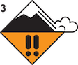
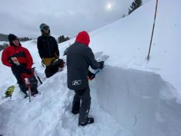
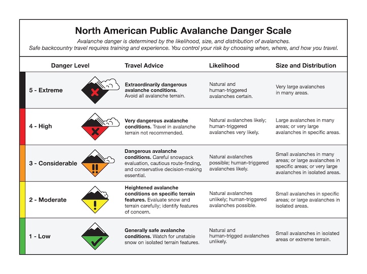
On slopes without a wind-load conditions will be better, but not perfect. Not much weight was added to the snowpack; however, we have a weak layer of faceted (sugary) snow buried 1-2 feet deep on many slopes that has the potential to avalanche. We found it on Saddle Peak and in Hyalite, and sledders found it on Buck Ridge. Dig down and look for this weakness before committing to avalanche terrain, and head to lower-angled slopes if you find it. For today, the avalanche danger is rated CONSIDERABLE on wind-loaded slopes and MODERATE on all others.

The southern mountains received 1-2” of snow with the exception of Taylor Fork where 6” (.2 SWE) fell with a light north wind. These mountains have a weak layer of faceted, sugary snow buried 2-3 feet deep which is active. A passing snowmobiler or skier can trigger this weakness which is evident by rumbling whumpfs, an avalanche on the flats. If flatter terrain is connected to steeper slopes an avalanche can be released (a.k.a. remote trigger). On Friday, Alex and his partner triggered a slope in Cooke City this way and posted a video and pictures on our Observations page. On Tuesday, Dave and I were in Lionhead (video) while Ian was further north in Bacon Rind (video). We both had audible whumpfs in the unstable snow. On slopes with wind drifts, this instability will be exacerbated because not only is the layer supporting more weight, but thicker slabs can allow avalanches to break wide. Whumpfs and shooting cracks are Mother Nature’s warning sign to stay off steep slopes. For today, triggering avalanches is possible and the avalanche danger is rated MODERATE.
If you get out, please share avalanche, snowpack or weather observations via our website, email (mtavalanche@gmail.com), phone (406-587-6984), or Instagram (#gnfacobs).

This morning we are measuring 4” of low density snow and light wind. The snowpack is deep in spots (video) and also has weaker facets buried about 2.5 feet under the surface (observation). Triggering avalanches is possible, especially on slopes that have been wind-loaded. Whumpfs, cracking or collapsing are signs that slopes are dangerous and should be avoided.
Submit your snow, avalanche and weather observations to contribute to the Island Park Trip Planning page.
Upcoming Avalanche Education and Events
Our education calendar is full of awareness lectures and field courses. Check it out: Events and Education Calendar.
TONIGHT, Thursday, December 15, 6:30 p.m., 1-Hour Avalanche Awareness at Uphill Pursuits. Free.
Saturday, December 17, 10 a.m., Avalanche Awareness - Winter Wonderland at Montana Science Center. More information HERE.
Monday, December 19, 5:30 p.m., Women in the Backcountry at MAP Brewing. Free.
Every Saturday, 10 a.m - 2:00 p.m. Avalanche Rescue Training, drop in for any amount of time. Round Lake Warming Hut, Cooke City. Free.
Send us your observations. They do not have to be fancy, just a few sentences. Did you see any avalanches? How much new snow? Is the wind blowing and drifting snow? Pictures, snowpits and stability test scores are also welcome, but not necessary. You can help us fill in the gaps of our field work.