This is Alex Marienthal with the Gallatin National Forest Avalanche Forecast on Wednesday, November 23rd at 7:15 a.m. This information is sponsored by Blitz Motorsports and Yamaha and Montana State Parks. This is our first daily forecast including danger ratings for the season. This forecast does not apply to operating ski areas.
*Note: Bridger Bowl Ski Area is closed and there is no avalanche control or ski patrol services. Backcountry conditions exist. Please don’t ski over hoses and power cords, stay off chairlifts, and give snowcats and snowmobiles plenty of room
This morning the mountains have a 1-4” of new snow, temperatures are teens to 20s F, and wind is westerly at 10-20 mph with gusts to 40 mph. Today, temperatures will be teens to mid-20s F with west-northwest wind at 15-25 mph and gusts to 35 mph. Snow will continue through today with 4-7” near Bozeman and Big Sky and 1-2” in the southern areas.

All Regions
Today avalanches are possible where drifts of new snow are created by moderate west-northwest wind. Skiers, snowmobilers, ice-climbers and hunters should be cautious of steep slopes that have dense drifts of snow. Watch for cracking across the snow surface as a clear sign that these drifts are unstable and should be avoided. Find alternate routes if you encounter terrain that has higher consequences of being caught in even a small slide, such as narrow gullies or steep slopes above cliffs or thick trees.
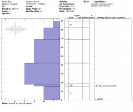
The mountains have 1-3 feet of snow on the ground which fell in late October and early November. A few recent avalanches are evidence that weakness can be found deeper in the snowpack. A large avalanche on Hyalite peak last Friday broke a couple feet deep and 150 feet wide (photo and details). Yesterday, Big Sky ski patrol triggered avalanches with large explosives that broke 12” deep, above a crust that formed on top of late-October snow (photos and details). Avoid buried persistent weak layers by digging to assess snowpack structure and stability before riding in steep terrain. We have not seen or had reports of widespread unstable buried weak layers which means assessment may be trickier. With a lack of clear unstable snowpack test results, remain cautious if you find buried weak layers that cause concern. Take a step back with today's storm and see which layers break in avalanches and snowpack tests after the added weight of new snow and drifts.
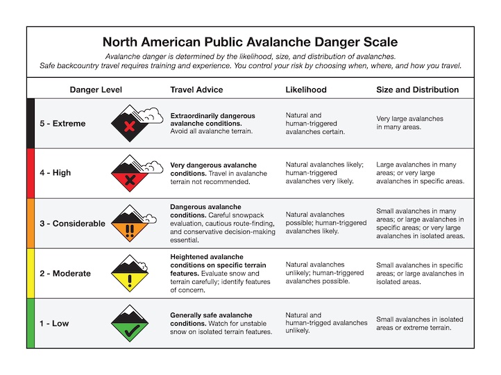
Today, avalanches are possible and avalanche danger is MODERATE.
Doug will issue the next forecast tomorrow morning. If you get out, please share avalanche, snowpack or weather observations via our website, email (mtavalanche@gmail.com), phone (406-587-6984), or Instagram (#gnfacobs). Snow Observations Page, Submit your observations.
Upcoming Avalanche Education and Events
Our education calendar is full of awareness lectures and field courses. Check it out: Events and Education Calendar.
We are offering an Avalanche Fundamentals with Field Session course for skiers in December and January, and snowmobilers in early January. Sign up early before they fill up.
The Friends of the Avalanche Center are hosting the Powder Blast Fundraiser. Your donations support free and low-cost avalanche education, beacon checkers at trailheads, beacon parks, weather stations, and GNFAC programs! The Friends of GNFAC launched an online GoFundMe campaign. Please consider a donation, and we look forward to having an in-person event again in the future.