Good morning. This is Ian Hoyer with the Gallatin National Forest Avalanche Forecast on Friday, February 4th, at 7:00 a.m. This information is sponsored by Blitz Motorsports and Yamaha and onX. This forecast does not apply to operating ski areas.
There is no new snow this morning. Temperatures are in the single digits and teens F. Winds are 15-25 mph out of the west and northwest with gusts of 35-45 mph. These winds will continue today as temperatures climb into the 30s F in the north and only into the teens F in the south. Today will be mostly sunny except around West Yellowstone where clouds will linger. A dusting of snow is possible tonight.
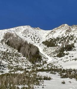
Strong winds have blown the 10” of snow that fell Monday and Tuesday into drifts which cracked under skiers and riders yesterday. A snowboarder in Hyalite yesterday triggered a very small (6” deep) avalanche on a small slope (photo). Drifting continued yesterday and strong winds will continue drifting snow today, creating fresh unstable drifts (photo). Look for cracks shooting out in front of your skis or snowmobile as a sign that you’ve found unstable snow and should stay off steep slopes. The new snow fell onto a weak snow surface. Quickly dig 1-2ft deep to check for unstable weak layers in the upper snowpack. The avalanche danger is MODERATE on wind-loaded slopes. On non-windloaded, the new snow is not deep or cohesive enough for large avalanches and the danger is LOW.
In the mountains around West Yellowstone and Cooke City less snow fell earlier in the week (5-6”) and winds have been slightly lighter. Any wind-drifted slabs will generally be small and harmless outside of the steepest and most exposed terrain. Yesterday, Alex and I found stable conditions in Teepee Basin (video) and Doug found the same at Bacon Rind (video). An avalanche on Wednesday outside Cooke City that broke a foot deep in a steep gully, carrying a skier 600 ft and partially burying them with their head under the snow is a reminder to keep your guard up even during low danger (details and photo). If you find an isolated area with more than a few inches of drifted snow, carefully evaluate the snowpack before committing to steep terrain. Weak layers near the surface remain on our list of concerns for when it snows again. For today, the avalanche danger is rated LOW because large avalanches are unlikely (but not entirely impossible).
If you get out, please send us your observations no matter how brief. You can submit them via our website, email (mtavalanche@gmail.com), phone (406-587-6984), or Instagram (#gnfacobs).
THIS SATURDAY: KING AND QUEEN OF THE RIDGE
Do you like to hike? Do you like to ski? Then the King & Queen of the Ridge is for you. Hike, ski and raise money for the Friends of the Avalanche Center in their 2nd biggest fundraiser of the year. Join the effort to promote and support avalanche safety and awareness! Fundraising prizes for top 5 individuals who raise over $500. No racing is necessary to compete for the fundraising prizes. Info is HERE. Race participants for the February 5th event must register separately with Bridger Bowl HERE.
Upcoming Education Opportunities
See our education calendar for an up-to-date list of all local classes. Here are a few select upcoming events and opportunities to check out:
TODAY, Dillon Montana Avalanche Fundamentals, three-part series of pre-recorded lectures, virtual Q&A and an in-person field session. Pre-registration and more information HERE.
TOMORROW, King and Queen of the Ridge at Bridger Bowl. Come hike and ski with your friends for avalanche awareness and fun! Details above.
February 10th, Forecaster Chat at Uphill Pursuits, “Beyond the Beacon” with GNFAC Forecaster Dave Zinn
Every Saturday near Cooke City, 10 a.m.-3 p.m. FREE snowpack update and transceiver/rescue training. Stop by for 20 minutes or more at the Round Lake Warming Hut.
Are you wanting to take an avalanche class? It can be a bit confusing trying to understand the different levels and types of classes. Sarah Carpenter explains it well in this article.


